Analytics
Land Acquisition Program (LAP)
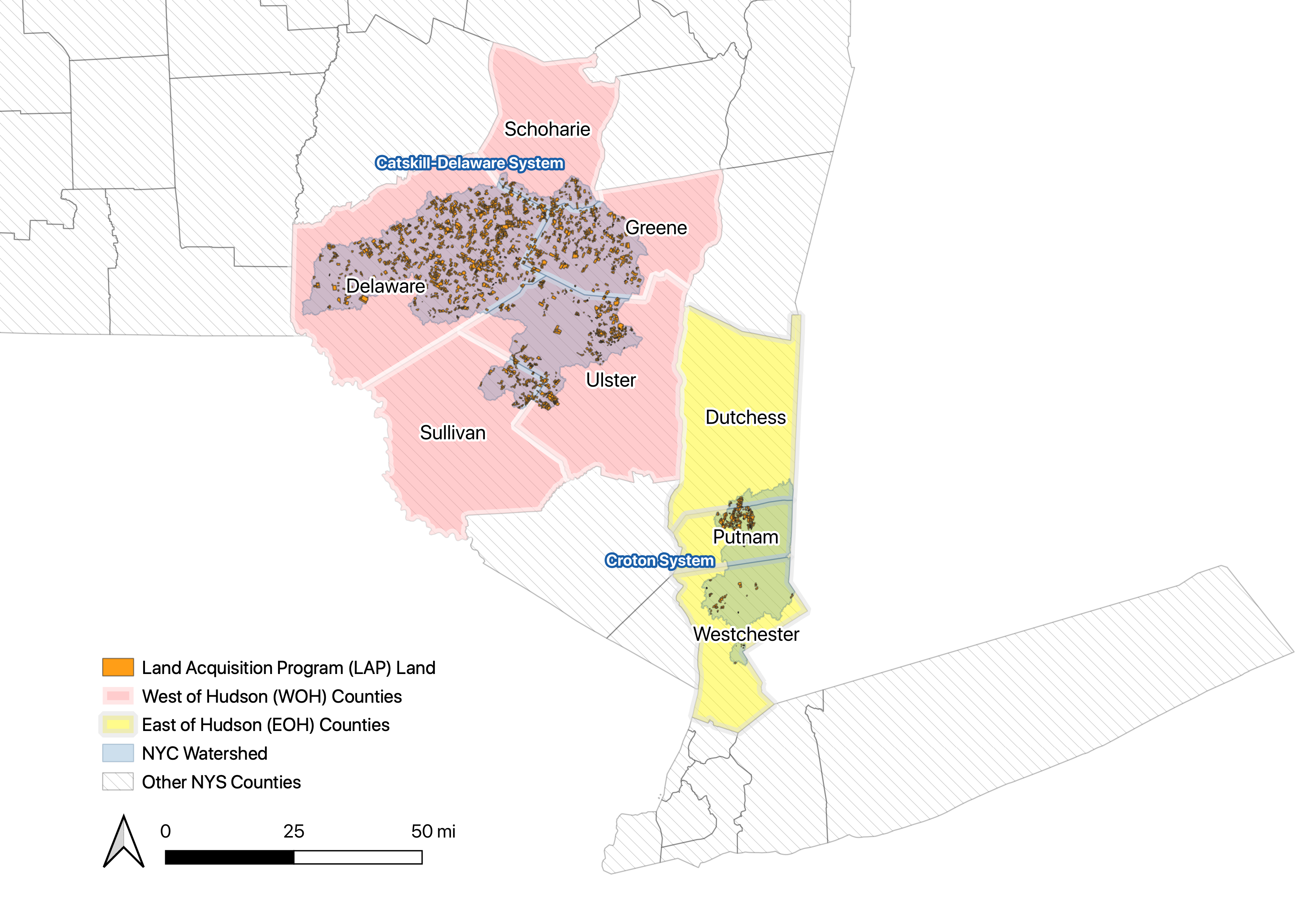
The goal of the New York City Land Acquisition Program (LAP) is to acquire fee simple and conservation easement interests to protect environmentally-sensitive land in the New York City (City) watershed as a part of the City’s overall Watershed Protection Program. LAP is a key component of the City’s efforts to continue to provide high quality drinking water without filtration of the Catskill-Delaware (Cat-Del) System, which provides water to over 9 million residents of the City and nearby communities in New York State. (NYC DEP, 2010)
Since its creation in the 1990s, LAP has protected, through acquisition, over 140,000 acres of land in the 1 million-acre Cat-Del System and over 11,000 acres of land in the Croton System. The land and easements acquired are to be maintained in perpetuity as open space for watershed protection.
Since its creation in the 1990s, LAP has protected, through acquisition, over 140,000 acres of land in the 1 million-acre Cat-Del System and over 11,000 acres of land in the Croton System. The land and easements acquired are to be maintained in perpetuity as open space for watershed protection.

LAP lands over the WOH Cat-Del System and EOH Croton System
Employment and Wage Trends
Under New York State's Unemployment Insurance (UI) Law, employment information by place of work is collected and consolidated under a product known as the Quarterly Census of Employment and Wages (QCEW) program. A cooperative program with the U.S. Bureau of Labor Statistics, QCEW data encompass approximately 97 percent of New York's nonfarm employment, providing a virtual census of employees and their wages as well as the most complete universe of employment and wage data, by industry according to the 2012 North American Industry Classification System (NAICS). More technical notes regarding QCEW data can be found here.
Trends for the 8 watershed counties are extracted and visualized below. The metrics available are:
Trends for the 8 watershed counties are extracted and visualized below. The metrics available are:
- Real Average Salary: total annual wages divided by the annual average employment and inflation-adjusted to 2018 levels using the US Bureau of Labor Statistics’s Consumer Price Index for All Urban Consumers of the New York-Newark-Jersey City regions
- Real Total Salary: all wages and salaries paid to individuals in insured employment, also inflation-adjusted to 2018 levels
- Establishments: usually a single place of business, which is engaged in a single business activity, and operated by a single employer
- Average Employment: arithmetic mean of the employment reported for all 12 months of the year. The employment count represents the number of full-time and part-time employees covered under the NYS UI program along with their earnings, wages, or salaries, for the payroll period including the 12th of the month.
Toggle the County and Economic Metric options to find out.
County:
Economic Metric:
LAP and Economic Correlations
Calculating the Pearson Correlation Score between annual employment and land acquisition statistics tells us about the nature and strength of relationship between policy and economic trends.
Visualized below are the correlations between annual QCEW data for each industry and county against the annual number of acres acquired within that county. For the West of Hudson counties (Delaware, Greene, Schoharie, Sullivan, Ulster), data on lands acquired can be further broken down into the four main land use types: Agricultural, Forest, Urban/Built Up lands and Others. Scroll down to view the annual QCEW and LAP data for each selected correlation value.
Interpretation of Correlation Score: A value close to 1 indicates a strong positive correlation between the two metrics, a value close to 0 indicates weak to no correlations while a value close to -1 indicates a strong negative correlation.
Toggle the "Economic Metric" and "LAP Land Use Type" options to find out.
Compute correlations between
Economic Metric: and
LAP Land Use Type:

